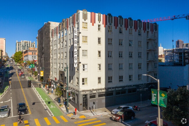
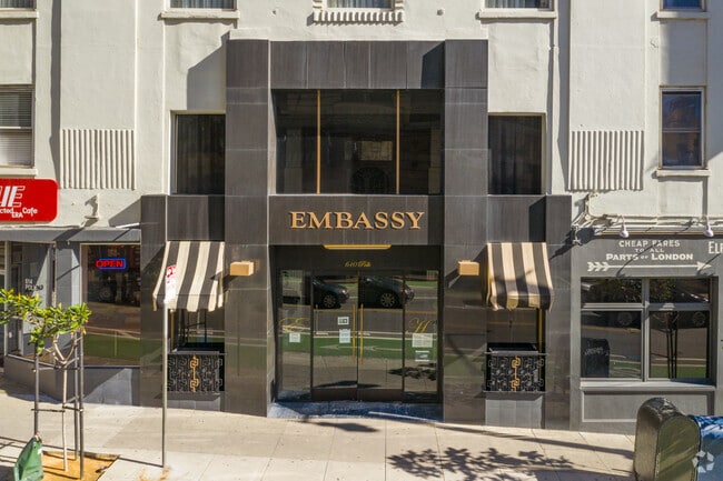
Property Record
622 Polk St, San Francisco, CA 94102

NEARBY LISTINGS FOR SALE OR LEASE
Property Detail
622 Polk St
San Francisco-Redwood City-South San Francisco, CA
Western Add Bl 07
0741-006B
San Francisco
Hotel
California
2024
6b
2025
0.10 AC
012406
San Francisco Market St
23,378 SF
San Francisco
DEMOGRAPHICS near 622 Polk St
1 Mile
3 Mile
5 Mile
2024 Total Population
141,966
472,692
727,519
2029 Population
132,549
440,806
672,884
Pop Growth 2024-2029
(6.63%)
(6.75%)
(7.51%)
Average Age
43
42
42
2024 Total Households
74,412
227,915
314,855
HH Growth 2024-2029
(7.26%)
(7.29%)
(7.86%)
Median Household Inc
$80,015
$132,280
$128,564
Avg Household Size
1.70
1.90
2.20
2024 Avg HH Vehicles
.00
1.00
1.00
Median Home Value
$1,042,230
$1,103,204
$1,101,624
Median Year Built
1951
1949
1949
Nearby Places
Map Layers
Map Styles
 Street
 Aerial
- Restaurants
- Banks
- Shops
- Fitness
- Groceries
PUBLIC TRANSPORTATION
TRANSIT/SUBWAY
Market And Hyde Outbound (F Market - San Francisco Municipal Railway (MUNI Metro))
DRIVE
WALK
Distance
Market And Hyde Outbound (F Market - San Francisco Municipal Railway (MUNI Metro))
2 min
9 min
0.5 mi
Civic Center Station (Dublin/Pleasanton - Millbrae - Bay Area Rapid Transit (BART), Fremont - Daly City - Bay Area Rapid Transit (BART), J Church - Bay Area Rapid Transit (BART), K Ingleside - Bay Area Rapid Transit (BART), L Taraval - Bay Area Rapid Transit (BART), M Ocean View - Bay Area Rapid Transit (BART), N Judah - Bay Area Rapid Transit (BART), Pittsburg/Bay Point - San Francisco International - Bay Area Rapid Transit (BART), Richmond - Millbrae - Bay Area Rapid Transit (BART), S Castro Shuttle - Bay Area Rapid Transit (BART), T Third Street - Bay Area Rapid Transit (BART))
DRIVE
WALK
Distance
Civic Center Station (Dublin/Pleasanton - Millbrae - Bay Area Rapid Transit (BART), Fremont - Daly City - Bay Area Rapid Transit (BART), J Church - Bay Area Rapid Transit (BART), K Ingleside - Bay Area Rapid Transit (BART), L Taraval - Bay Area Rapid Transit (BART), M Ocean View - Bay Area Rapid Transit (BART), N Judah - Bay Area Rapid Transit (BART), Pittsburg/Bay Point - San Francisco International - Bay Area Rapid Transit (BART), Richmond - Millbrae - Bay Area Rapid Transit (BART), S Castro Shuttle - Bay Area Rapid Transit (BART), T Third Street - Bay Area Rapid Transit (BART))
5 min
9 min
0.5 mi
Market And 7Th/Jones (F Market - San Francisco Municipal Railway (MUNI Metro))
DRIVE
WALK
Distance
Market And 7Th/Jones (F Market - San Francisco Municipal Railway (MUNI Metro))
4 min
9 min
0.5 mi
Metro Civic Center Station/Downtn (CHURCH - San Francisco Municipal Transportation Agency, INGLESIDE - San Francisco Municipal Transportation Agency, JUDAH - San Francisco Municipal Transportation Agency, OCEAN VIEW - San Francisco Municipal Transportation Agency, TARAVAL - San Francisco Municipal Transportation Agency)
DRIVE
WALK
Distance
Metro Civic Center Station/Downtn (CHURCH - San Francisco Municipal Transportation Agency, INGLESIDE - San Francisco Municipal Transportation Agency, JUDAH - San Francisco Municipal Transportation Agency, OCEAN VIEW - San Francisco Municipal Transportation Agency, TARAVAL - San Francisco Municipal Transportation Agency)
3 min
9 min
0.5 mi
Van Ness (Metro) (J Church - San Francisco Municipal Railway (MUNI Metro), K Ingleside - San Francisco Municipal Railway (MUNI Metro), L Taraval - San Francisco Municipal Railway (MUNI Metro), M Ocean View - San Francisco Municipal Railway (MUNI Metro), N Judah - San Francisco Municipal Railway (MUNI Metro), S Castro Shuttle - San Francisco Municipal Railway (MUNI Metro), T Third Street - San Francisco Municipal Railway (MUNI Metro))
DRIVE
WALK
Distance
Van Ness (Metro) (J Church - San Francisco Municipal Railway (MUNI Metro), K Ingleside - San Francisco Municipal Railway (MUNI Metro), L Taraval - San Francisco Municipal Railway (MUNI Metro), M Ocean View - San Francisco Municipal Railway (MUNI Metro), N Judah - San Francisco Municipal Railway (MUNI Metro), S Castro Shuttle - San Francisco Municipal Railway (MUNI Metro), T Third Street - San Francisco Municipal Railway (MUNI Metro))
2 min
11 min
0.6 mi
COMMUTER RAIL
San Francisco 4Th & King (Caltrain - Caltrain (Caltrain))
DRIVE
WALK
Distance
San Francisco 4Th & King (Caltrain - Caltrain (Caltrain))
5 min
1.8 mi
San Francisco Caltrain Station Southbound (Express - Caltrain (Caltrain), Limited - Caltrain (Caltrain), Local Weekday - Caltrain (Caltrain), Local Weekend - Caltrain (Caltrain))
DRIVE
WALK
Distance
San Francisco Caltrain Station Southbound (Express - Caltrain (Caltrain), Limited - Caltrain (Caltrain), Local Weekday - Caltrain (Caltrain), Local Weekend - Caltrain (Caltrain))
5 min
1.9 mi
AIRPORT
San Francisco International
DRIVE
WALK
Distance
San Francisco International
23 min
13.5 mi
Metro Oakland International
DRIVE
WALK
Distance
Metro Oakland International
32 min
20.2 mi
Freight Ports
Port of San Francisco
DRIVE
WALK
Distance
Port of San Francisco
7 min
2.5 mi
SALE & LEASE HISTORY
LISTING DATE
SALE/LEASE

Jun 02, 2023
For Sale
Nearby Properties
Address
Land Use
TOTAL SIZE
Lot Size
Zoning
Address
Land Use
TOTAL SIZE
Lot Size
Zoning
1,015,000 SF
2.43 AC
RC4
Address
Land Use
TOTAL SIZE
Lot Size
Zoning
764,661 SF
0.67 AC
C3OSD
Address
Land Use
TOTAL SIZE
Lot Size
Zoning
750,370 SF
3.25 AC
MBR3
Address
Land Use
TOTAL SIZE
Lot Size
Zoning
1,471,929 SF
1.93 AC
C3O
Address
Land Use
TOTAL SIZE
Lot Size
Zoning
1,300,000 SF
1.74 AC
C3O
Address
Land Use
TOTAL SIZE
Lot Size
Zoning
1,420,430 SF
1.16 AC
C3OSD
Address
Land Use
TOTAL SIZE
Lot Size
Zoning
1,534,312 SF
2.60 AC
C3O
Address
Land Use
TOTAL SIZE
Lot Size
Zoning
914,037 SF
1.36 AC
C3O
Address
Land Use
TOTAL SIZE
Lot Size
Zoning
248,303 SF
4.35 AC
Address
Land Use
TOTAL SIZE
Lot Size
Zoning
717,234 SF
3.47 AC
UMU
Address
Land Use
TOTAL SIZE
Lot Size
Zoning
605,459 SF
0.63 AC
C3O
Address
Land Use
TOTAL SIZE
Lot Size
Zoning
475,791 SF
0.55 AC
C3OSD
Address
Land Use
TOTAL SIZE
Lot Size
Zoning
690,442 SF
0.79 AC
C3O
Address
Land Use
TOTAL SIZE
Lot Size
Zoning
10.92 AC
Address
Land Use
TOTAL SIZE
Lot Size
Zoning
750,491 SF
0.51 AC
C3O
Address
Land Use
TOTAL SIZE
Lot Size
Zoning
432,000 SF
0.35 AC
C3OSD
Address
Land Use
TOTAL SIZE
Lot Size
Zoning
266,143 SF
4 AC
C-3-R
Address
Land Use
TOTAL SIZE
Lot Size
Zoning
885,581 SF
5.20 AC
M2
Address
Land Use
TOTAL SIZE
Lot Size
Zoning
512,395 SF
1.24 AC
C3O
Address
Land Use
TOTAL SIZE
Lot Size
Zoning
508,714 SF
1.29 AC
C3R
Address
Land Use
TOTAL SIZE
Lot Size
Zoning
1,084,662 SF
1.67 AC
C3O
Address
Land Use
TOTAL SIZE
Lot Size
Zoning
505,120 SF
0.41 AC
C3O
Address
Land Use
TOTAL SIZE
Lot Size
Zoning
694,334 SF
1.01 AC
C3O
Address
Land Use
TOTAL SIZE
Lot Size
Zoning
696,431 SF
0.97 AC
C3G
Address
Land Use
TOTAL SIZE
Lot Size
Zoning
139,070 SF
0.64 AC
C3O
Address
Land Use
TOTAL SIZE
Lot Size
Zoning
1.52 AC
C3G
Address
Land Use
TOTAL SIZE
Lot Size
Zoning
1,424,230 SF
2.60 AC
C3G
Address
Land Use
TOTAL SIZE
Lot Size
Zoning
614,740 SF
1.74 AC
C3OSD
Address
Land Use
TOTAL SIZE
Lot Size
Zoning
615,957 SF
0.63 AC
C3O
Address
Land Use
TOTAL SIZE
Lot Size
Zoning
492,980 SF
0.43 AC
C3O
The World's #1 Commercial Real Estate Marketplace
Connect with us
© 2025 CoStar Group
The information above has been obtained from sources believed reliable. While we do not doubt its accuracy we have not verified it and make no guarantee, warranty or representation about it. It is your responsibility to independently confirm its accuracy and completeness. Any projections, opinions, assumptions, or estimates used are for example only and do not represent the current or future performance of the property. The value of this transaction to you depends on tax and other factors which should be evaluated by your tax, financial, and legal advisors. You and your advisors should conduct a careful, independent investigation of the property to determine to your satisfaction the suitability of the property for your needs.